Our Location
Discover Anthony’s Key Resort in Roatan, Honduras
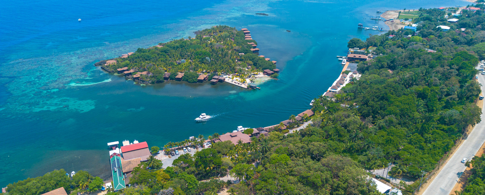
Located in Sandy Bay on the northwestern shore of Roatan, Anthony’s Key Resort offers a unique Caribbean setting that blends the convenience of the main island with the tranquility of a private island experience.
Guests arrive at the resort’s reception, located on the main island of Roatan, where the greater part of the resort’s property is situated. This area is home to most of the resort’s central amenities, including the dive shop, Ankor Seafood Grill, Frangipani Bar & Lounge, Seaside Gift Shop, Dockside Lofts, and Hill Superior bungalows.
Just offshore, approximately 69 meters from the main island, sits Anthony’s Key itself, a lush 9-acre private key surrounded by the Caribbean Sea. A short island taxi boat ride connects guests between the main island and the key throughout the day, becoming part of the experience from the moment you arrive.
Anthony’s Key is home to the resort’s waterfront accommodations, including the Key Superior bungalows, Key Deluxe bungalows, and Key Premium Suites. The key also features the resort’s freshwater pool, Ixora Spa, fitness center, and peaceful pathways lined with tropical landscaping and panoramic ocean views.
Where Is Roatan?
Roatan is the largest of Honduras’ Bay Islands, located in the western Caribbean Sea approximately 40 miles off the northern coast of Honduras. Known for its warm waters, vibrant coral reefs, and relaxed atmosphere, Roatan is one of the Caribbean’s premier destinations for scuba diving and snorkeling.
The island sits along the Mesoamerican Barrier Reef System, the second-largest barrier reef in the world, placing exceptional reef diving and snorkeling just minutes from Anthony’s Key Resort’s dock.
Located in Sandy Bay
Anthony’s Key Resort is located in Sandy Bay, one of Roatan’s most scenic and established communities. Known for its calm waters and lush tropical surroundings, Sandy Bay offers a quieter, more relaxed atmosphere than the island’s busier tourist districts, while still being centrally located for exploring Roatan.
The resort is conveniently located near:
- West End Village
- Carambola Botanical Gardens
- The Roatan Institute for Marine Sciences (RIMS)
- Local restaurants and beach bars
- Popular island tours and attractions
Easy Access to Paradise
Anthony’s Key Resort is approximately 20 to 30 minutes from Juan Manuel Galvez International Airport (RTB).
Direct international flights connect Roatan with major cities across the United States, Canada, and Central America, making travel to the island easier than many visitors expect. Round-trip airport transfers are included with most stays.
A Caribbean Escape Connected to Nature
At Anthony’s Key Resort, location is part of the experience itself. Wake up steps from the Caribbean Sea, board a dive boat just minutes from the reef, kayak through calm tropical waters, or relax in a hammock surrounded by palms and ocean breezes.
Whether visiting for diving, snorkeling, family travel, or a peaceful tropical getaway, Anthony’s Key Resort offers a setting that feels both connected to Roatan and completely removed from the ordinary.
Getting To Roatan
Easy to reach. Hard to leave.
Roatan is served by Juan Manuel Galvez International Airport (RTB), with direct flights from major cities across the United States, Canada, and Central America. Most routes are under three hours from key gateways, making travel to Roatan easier than many Caribbean destinations.
Round-trip airport transfers to Anthony’s Key Resort are included with most stays, and the resort is located approximately 20–30 minutes from the airport.
Looking for detailed flight routes, domestic connections, baggage tips, and travel advice?
Visit our complete guide to Getting to Roatan.