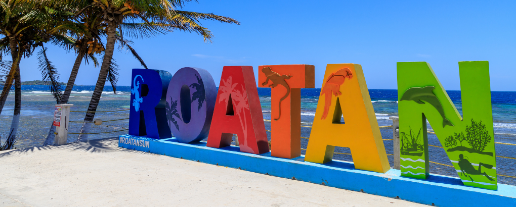
About Roatan
Roatan’s Location
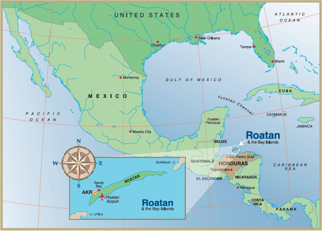
Roatan is located in the Western Caribbean (16°S, 86°W), approximately 35 miles (56 km) north of mainland Honduras. Roatan is the largest and most developed of the Bay Islands, with an area of 49 sq. Miles (12,740 hectares). It has a 30-mile-long E-W axis and a 1-2-mile-wide N-S axis. The other main islands are Guanaja (29 sq. miles) and Utila (16 sq. miles). These islands form a 75-mile (120 km) crescent along with three smaller islands of Helene, Morat, and Barbareta, and 65 smaller keys, of which you’ll find 23 of them off the shores of Roatan.
Roatan’s Topography: A Mountainous Terrain
Roatan has a mountainous backbone; only 2% is considered level (less < 5% grade). Its steep peaks, some rising as high as 1,300 feet, make the island poorly suited for agriculture. While most of the island has slopes between 30 and 75%, some areas reach 90%. Most level areas are swampy.
Climate and Weather Patterns in Roatan
Roatan enjoys warm temperatures year-round, typically ranging from 77 to 88 °F. The rainy season runs from October through February, when most of the island’s annual rainfall occurs and can total more than 6 feet (about 2,000 mm). The dry season varies each year slightly but generally lasts about three months, with much lower rainfall from February through June, totaling less than 100 mm (about 4 inches), and the driest conditions occurring from March to May. Sea temperatures remain comfortably warm and clear year-round, averaging 78-84 °F.
Wind and Humidity: Roatan’s Atmospheric Conditions
The Bay Islands lie in the trade wind belt, and east-to-southeast trade winds with 19 to 26 mph velocities are relatively constant. Periods of up to 5 days of dead calm are common in August, and each winter, 5 to 7 North American cold fronts (“northers”) reach the islands, bringing wind shifts to the north and west, overcast skies, and prolonged rainfall. On the islands’ northern coast, winds typically blow from the east. The almost continuous influence of trade winds results in a characteristic condition of high relative humidity. While Roatán lies farther west than the paths of most Atlantic hurricanes, one large one is estimated to occur every 10 years. Before Hurricane Mitch in 1998, Hurricane Fifi in 1974 was the worst in recent times: wind speeds reached over 100 miles per hour, and over 20 inches of rain fell.
Flora: Roatan’s Rich Botanical Diversity
The island’s vegetation has been modified over the years as agriculture and the introduction of exotic species (cashews, mangos, almonds) have occurred. Despite the alteration, the warm, moist climate still supports a lush diversity of plant life. Over 50% of the island is under some forest cover. Several vegetative types prevail. Primary, secondary, mixed, and pine forests are found on the higher ridges. Located on the lower valley slopes are small rainforests, like growths of tall hardwoods, dense palms, lianas, orchids, and ferns. A thorn-scrub association is somewhat widespread in Roatan. There are also several areas of concentrated mangrove cover and beach vegetation around the island. The native pines and oaks that inspired Columbus to name the Bay Islands after them still exist, though they no longer cover such a large area. Other native species include the gumbo-limbo, cecropia, strangler fig, and many different palms. The trunks and branches of each tree are home to a variety of orchids, lianas, ferns, and bromeliads. Drier sites are home to acacia and mimosa, both with sharp thorns.
Roatan’s Wildlife: A Haven for Endemic Species
The terrestrial ecosystems on Roatan support abundant wildlife. While many species found here are the same as those on the mainland, the Bay Islands’ isolation has allowed some endemic species to evolve. There are presently nine species and two subspecies of animals endemic to the Bay Islands. Some of these species are the Roatán Parrot (Amazona xantholora), the Roatán Agouti (Dasyprocta ruatanica), the Roatán Coral Snake (Micrurus ruatanica), the Marmosa (Marmosa ruatanica) (mouse opossum), and the Rosy Boa (Boa constrictor). Five species are mollusks, as described by Professor Emilio Garcia of Louisiana State University in cooperation with RIMS. Wildlife that is extinct or extirpated from the Bay Islands includes the Caribbean Monk Seal (now extinct), the West Indian Manatee, and the Brown and Red-Footed Boobies.
Embracing Roatan’s Natural Beauty
We reflect on the remarkable tapestry of Roatan’s attributes. Nestled in the Western Caribbean, this island is a symphony of nature, with rugged mountains, lush forests, and diverse wildlife, including several endemic species. Its climate, shaped by trade winds and seasonal variations, adds to the island’s allure, creating a haven for adventure and relaxation. The unique blend of geographical features and rich biodiversity underscores Roatan’s status as a Caribbean jewel. As we consider its delicate ecosystems and the rare beauty they harbor, there’s a compelling call for mindful exploration and conservation. Roatan isn’t just a destination; it’s a vibrant, living ecosystem that invites us to immerse ourselves in its natural splendor while advocating for its preservation.
About The Bay Islands
Bay Islands
The Bay Islands lie in the trade wind belt, and east-to-southeast trade winds with 19 to 26 mph velocities are relatively constant. Periods of up to five days of dead calm are common in August, and each winter, five to seven North American cold fronts (“northers”) reach the islands, bringing wind shifts to the north and west, overcast skies, and prolonged rainfall. On the northern coast of the islands, winds typically blow from the east. The almost continuous influence of trade winds results in a characteristic condition of high relative humidity. While Roatán lies further west than the paths of most Atlantic hurricanes, one large one is estimated every ten years. Before Hurricane Mitch in 1998, Hurricane Fifi in 1974 was the worst in recent times: wind speeds reached over 100 miles per hour, and over 20 inches of rain fell.
Roatan has a mountainous backbone; only 2% is considered level (less < 5% grade). Its steep peaks, some rising as high as 1,300 feet, make the island poorly suited for agriculture. While the majority of the island possesses slopes between 30 and 75%, they can attain slopes of 90% in some areas. Most level areas are swampy.
Over the years, the island’s vegetation has been modified, and agriculture and exotic species have been introduced (cashews, mangos, almonds). Despite the alteration, the warm, moist climate still supports a lush diversity of plant life. Over 50% of the island is under some forest cover. Several vegetative types prevail. Primary, secondary, mixed, and pine forests are found on the higher ridges. Located on the lower valley slopes are small rainforests like growths of tall hardwoods, dense palms, lianas, orchids, and ferns. A thorn-scrub association is somewhat widespread in Roatan. There are also several areas of concentrated mangrove cover and beach vegetation around the island. The native pines and oaks that impressed Columbus into naming the Bay Islands after them, although they still exist, no longer cover such an extensive area. Other native species include the gumbo-limbo, cecropia, strangler fig, and many different palms. The trunks and branches of each tree are home to a variety of orchids, lianas, ferns, and bromeliads. Drier sites are home to acacia and mimosa with their sharp thorns.
The terrestrial ecosystems on Roatan support an abundance of wildlife. While many species found here are the same animals on the mainland, the Bay Islands’ isolation has allowed some endemic species to evolve. There are presently nine species and two sub-species of animals endemic to the Bay Islands. Some of these species are the Roatan Parrot (Amazona xantholora), the Roatán Agouti (Dasyprocta ruatanica), the Roatán Coral Snake (Micrurus ruatanica), the Marmosa (Marmosa ruatanica) (mouse opossum), and the Rosy Boa (Boa constrictor). Five species are mollusks, as described by Professor Emilio Garcia of Louisiana State University in cooperation with RIMS. Wildlife that is extinct or extirpated from the Bay Islands includes the Caribbean Monk Seal (now extinct), the West Indian Manatee, and the Brown and Red-Footed Boobies.
The Bay Islands Department (political sub-division), created in 1872, is Honduras’ most northern and completely insular department. In the 1992 national census, it was suggested that the population of the Bay Islands was upwards of 30,000 people, with the majority, about 66.2 %, living in Roatán. A recent census suggests the population has grown to 100,000. The major population centers in Roatán are Coxen Hole, French Harbor, and Oak Ridge. Smaller towns include West End, Sandy Bay, and Punta Gorda. Most people on the island are bilingual (Spanish and English) and come from a cultural heritage of English descent, African Caribbean, Indian, and Central and North American. You will also hear the dialects of Garifuna and Creole. Roatan is the only Bay Island with an extensive road and communication system. The number of tourists that visit the Bay Islands annually now exceeds the population. This tourism is based principally on scuba diving. In 1969, about 900 tourists visited these islands for diving-related recreation. That number increased to 8,000 in 1988 and doubled to 17,000 by 1992. With the expansion of the airport runway in 1990 and the completion of the first cruise ship terminal in 2000, that number has increased substantially, and according to recent estimates, the number of tourists now exceeds 250,000 per year.
When the Government of Honduras declared the Bay Islands a “tourist zone” on March 30, 1982, the major regulatory authority for conserving the Bay Islands was transferred to the Honduran Ministry of Culture and Tourism. Growing concern over the critical balance between environmental health and economic prosperity in the Bay Islands has led to several plans that address conservation and initiatives to increase tourism. Efforts include several studies of the Bay Island’s marine ecosystems, studies on watershed management and forest protection, and work currently underway at RIMS. The Bay Islands’ most important conservation efforts are still in production: a governmental initiative to develop an environmental management plan to help achieve sustainable development and prevent the deterioration of the natural resources of the Bay Islands.
About Honduras
Honduras
Honduras is a small, peaceful Central American country bordered by Guatemala, El Salvador, and Nicaragua. It is the second-largest country in Central America and has almost 112,000 square kilometers (roughly the size of Tennessee) of mountains and coastal plains. Dozens of rivers cascade down from the mountains to the wide Caribbean coast and narrow Pacific plain.
Honduras’ Bay Islands, including Roatan, lie off its Caribbean coast and are the focal point of Honduras’ growing tourism industry. Here, divers and snorkelers indulge in the splendor of the hemisphere’s longest barrier reef system.
Honduras and the Bay Islands will satisfy the most active and adventurous travelers with beautiful beaches, crystalline waters, untouched natural wonders, and cultural encounters with ancient and colonial worlds.
Honduras History
Pre-Columbian Honduras was home to at least six known groups, including the advanced Maya, the Lenca, and the Miskitos. The Maya were dominant on the mainland of Honduras, where their ruins can still be found. Honduras’ history changed when Columbus explored the area in 1502. While the Spanish settled the region, both the Spanish and the English fought for dominance in the region for several centuries. In 1821, Honduras, Mexico, and three other Central American nations declared their independence from Spain. In 1838, Honduras left this federation and became independent.
Honduras Today
The capital of Honduras is Tegucigalpa, located in the southwestern part of the country. Its population is roughly 8 million people, and the official language is Spanish, but many Amerindian dialects are also spoken, along with English in the Bay Islands.
Industries and natural resources in Honduras include sugar, coffee, textiles, clothing, fishing, timber, gold, silver, copper, and metals.
Today, Honduras is a democratic constitutional republic.